Wednesday, September 21, 2011
Speeches
Brrrrrrrrrrr!!!! I do not like speeches. But I did pesevere, abnd did it. My speech waws on the rugby world cup. I told the class some info about it, and other stuff.
Thursday, September 15, 2011
RWC
Yes! RWC has finally started! I have been waiting, and waiting, and waiting, and waiting, and waiting, and waiting, and waiting, and waiting, and waiting, and waiting, and waiting, and waiting, and waiting, and waiting, and waiting, and waiting, and waiting, and waiting, and waiting, and waiting, and waiting, and waiting, and waiting, and waiting, and waiting, and waiting, and waiting, and waiting, and waiting, and waiting, (Or waiting x30). I am hoping that the All Blacks, will win the Webb Allis/Allice (Don't know how to spell it.)cup!!!
YEAH!!!
YEAH!!!
Wednesday, September 14, 2011
Writing a procedural writing
Yesterday we started to do some procedural writing. Once we've finished, we had to do it on the computer. Well I don't!!! That's beacuse I drew some pictures in my book, and gave it some stuff that I like, that I can't do on the computer. So all I have to do, is cut it out of my writing book!!! :)
Tuesday, September 13, 2011
Wednesday, September 7, 2011
Cricket
Today, we went out to practise cricket with this guy called Mitchel from NZ cricket. First we played a game called snowball tag, which is pretty much ball tiggy, just the more people tagged, the more people are in. Then we played a game which was really fun. What you had to do, was throw the ball up in the air, then see how many times you can clap and then catch the ball. After we played a game where there were some batters, and there were some fielders. The batters had to whack 2 balls of a thing in the ground, and the fielders would try and get the balls and put them back on the things. In that time, the batter had to run too a certain palce, and back, to see how many times he/she could run. And guess what? My team won!!!
Thursday, September 1, 2011
Spelling
Today, the class had to do spelling... except me!!! That's because I am to good at spelling. And just listening to Mrs W I can tell I know the words!!!
Tsunami
Wairarapa earthquake tsunamis, 1855
On 23 January 1855, a magnitude 8.1–8.2 earthquake, the most powerful to strike New Zealand since European settlement, shook the lower North Island. It generated not one, but several types of tsunami.
During the earthquake, the entire region west of the Wairarapa fault lurched abruptly north-east. Like soup in a bowl that is jostled, the water of Wellington Harbour slopped onto the adjacent land. The next movement of water occurred because the entire Wellington region had tilted – the eastern side of the harbour was now about 80 centimetres higher than the western side. The harbour waters ponderously moved off downhill, towards central Wellington. Houses and shops were flooded along Lambton Quay, which at that time was along the shore.
The greatest tsunami, however, was generated in Cook Strait. The Rimutaka Range rose as much as 6 metres, and part of the floor of the strait was probably uplifted. The tsunami destroyed sheds more than 8 metres above the sea at Te Kopi, on the southern Wairarapa coast. It moved along the strait and up the Kapiti coast – stranding fish as far north as Ōtaki – and spread across to the South Island.
Many turns of the tide
The sloop Pandora was anchored in Wellington Harbour at the time of the 1855 earthquake. Her commander, Byron Drury, reported: ‘For eight hours subsequent to the first and great shock, the tide approached and receded from the shore every 20 minutes, rising from eight to ten feet and receding four feet lower than at spring tides. One ship, I heard, was aground at her anchorage four times.
About 20 minutes after the earthquake, tsunami waves surged into Wellington Harbour through its narrow entrance, then for many hours bounced repeatedly back and forth, reflected off the harbour sides. Water also flooded into Lyall Bay from Cook Strait and Evans Bay from Wellington Harbour, putting the low isthmus between them (the site of Wellington Airport) under nearly a metre of water.
Falling bombs???
Falling bombs?
This is Paul De Rungs in 2006. In June 1942, when an earthquake struck, he was seven years old and living in an orphanage, the Anglican Boys’ Home, in Lower Hutt.
Contributed by Paul De Rungs of Auckland.
I don't know what time it was, but possibly in the early hours of the morning, eight of us boys in the dormitory were awakened by a very loud rumbling which was quite terrifying. All the more so because at that time there was a very real threat of a Japanese invasion. My first thought was that a huge squadron of Japanese bombers was flying directly overhead. These thoughts were further intensified when there was a very violent shaking which seemed to last several minutes. I thought these were explosions from falling bombs and we could get hit very soon.
The matron and her staff came around with torches, and did her best to calm us and explain that we were suffering an earthquake. I remember that after the first major jolt there were several others which followed, but not as severe as the first one.
When we got up in the morning and walked to our local school, the Eastern Hutt School, there were scenes of chaos all about us. Chimneys had toppled, shop windows had exploded outwards onto the street, and window displays were in complete disarray. The Self Help grocery shop seemed to suffer the worst damage. Power lines were down and there were cracks in the pavements and on the road.
We used to return back to the orphanage for lunch before returning to school. I think that it may have been a day or two after the major quake that we suffered another smaller one. I was walking back to the home for lunch with my best friend Tommy Dale, when another quake struck. We were at that moment right outside the Self Help grocery, its windows now boarded up. I was terrified and started crying, as did my mate Tommy. We clutched each other for support while the shaking continued. As soon as it stopped, we ran crying all the way back to the home. This is an experience that I will never forget. Some months after the quake a lot of the damage was still evident.
 ]
]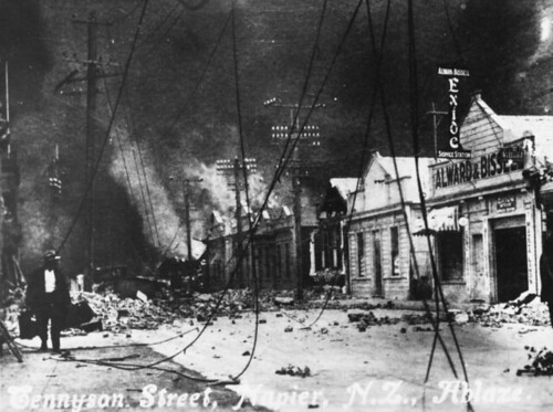

The 1931 Hawke’s Bay earthquake
The 1931 Hawke’s Bay earthquake
In 1931, New Zealand’s deadliest earthquake devastated the cities of Napier and Hastings. At least 256 people died in the magnitude 7.8 earthquake – 161 in Napier, 93 in Hastings, and 2 in Wairoa. Many thousands more required medical treatment.
256 or 258?
The official death toll of the Hawke's Bay earthquake is 256. But there are 258 names on the memorial, and this unofficial number is likely to be correct.
On Tuesday morning, 3 February 1931, at 10.47 a.m., the ground in the Hawke’s Bay region heaved sharply upward and swayed. A deceptive half-minute pause was followed by a downward motion and violent shaking and rocking. In all, the quake spanned two and a half minutes.
Fatalities
As buildings began to disintegrate, many people fled outdoors into a lethal rain of chunks from ornate facades, parapets and cornices. Buildings swayed violently, and their walls bulged and collapsed into the streets in avalanches of brick and masonry that crushed vehicles and people. Roofs caved in on buildings that had large open internal areas, such as churches, libraries and theatres. In some buildings the internal floors pulled free of the swaying walls, collapsing inward in a jumble of girders, wood and plaster.
In Napier, the recently built Nurses’ Home collapsed, killing clerical staff and off-duty nurses who were sleeping. In Hastings at least 50 people were in Roach’s department store when it collapsed; 17 died and many were seriously injured. The entire front of the five-storey Grand Hotel in Hastings crumbled into Heretaunga Street, claiming eight lives. Fifteen died at the Park Island Old Men’s Home near Taradale, but a 91-year-old man was pulled alive from the rubble three days later.
The Tangiwai and Ruapehu disaster
The Tangiwai and Ruapehu disaster
Poised for disaster
Mt Ruapehu erupted in 1945, but by the end of the year the excitement was over. The crater, about 300 metres deep, slowly refilled with water. The mountain did not seem dangerous, and it was no longer being monitored. By 1953, however, Crater Lake was 8 metres higher than its level before 1945. Few realised that the water was now held in by an unstable mass of ice and volcanic rubble and ash.
The lahar
At 8 p.m. on Christmas Eve 1953, the debris at the outlet of Crater Lake collapsed. About 340,000 cubic metres of water poured into the head of the Whangaehu River and swept down the valley, picking up sand, silt and boulders as it went. Soon after 10 p.m. this volcanic mud flow, known as a lahar, smashed into the main trunk railway bridge at Tangiwai. The concrete piers were knocked out and the bridge partially collapsed.
Driving through the darkness, Cyril Ellis stopped when he saw that the bridge ahead was under water, even though there had been no rain. Realising that a train was approaching the nearby rail bridge, he ran along the track towards it, waving a torch to flag it down. It was the passenger express from Wellington, packed with 285 people heading to Auckland for the holidays.
The train reaches the bridge
The driver saw him and applied the brakes, but the train’s momentum carried it out onto the bridge. The engine and first carriage nosedived, landing against the opposite bank. Four more carriages plunged into the river, floating in the torrent briefly before sinking. Another four carriages remained on the track, but one of them dangled over the river. Ellis and guard William Inglis attempted to help people off, but the coupling snapped and the carriage toppled into the river. Rolling several times, it came to rest on its side, with water flowing through it. Ellis knocked out several windows and hoisted people outside as passenger John Holman lifted fellow travellers out to him. In all, 26 people escaped, huddled on the carriage for over an hour until the torrent subsided. The men then formed a human chain in waist-deep water, helping everyone reach the bank safely.
On the other side of the flooded road bridge, Arthur Bell and his wife had also seen the train crash into the river. Mrs Bell went for help, while Arthur assisted 15 people from the carriage that had hit the riverbank.
New Zealand flood
New Zealand number 1 hazard
Floods are the most frequent and costly natural disasters in New Zealand – between 1920 and 1983, the country experienced 935 damaging floods. The Insurance Council of New Zealand calculated that industry payments for flood damage between 1976 and 2004 averaged $17 million per year in 2004 dollars. But this covers just part of the actual cost – for example, government expenditure on civil defence responses during flood emergencies alone averages about $15 million per year over the same period.
Early floods
Floods have cost an uncounted number of lives. Māori history tells of a pre-European flood in the Tūtaekurī area of Hawke’s Bay in which a party of 50 men, women and children were drowned by the rising of two streams. The early European settlers failed to realise the intensity of rainfall in New Zealand and how rapidly rivers could rise. The broad gravel-bed rivers were particularly deceptive: although usually shallow enough to wade across, in flood their currents become powerful. By 1870, just a few decades after European settlers first arrived, rivers had been responsible for 1,115 recorded drownings. Drowning became known as ‘the New Zealand death’.
A god’s revenge
Māori legend includes a story of a great flood. Tāwhaki, god of thunder and lightning, was almost murdered by his brothers-in-law. When he had recovered, Tāwhaki took his warriors and their families, and built a fortified village on top of a mountain. Then he called to his ancestors – the gods – for revenge, and they let the floods of heaven descend. The earth was overwhelmed by the waters and the entire population perished. This was known as Te hurihanga i Mataaho (the overwhelming of Mataaho – one of the places that were destroyed).
Causes
Most floods occur when water from intense or persistent rain, and sometimes from melting snow, enters rivers, streams and lakes, causing them to overflow. In New Zealand, the heaviest rain commonly accompanies tropical cyclones, depressions and frontal systems. Tropical cyclones, such as the storm of 28 January 1936 (considered New Zealand’s worst storm in the 20th century) and Cyclone Bola in 1988, have caused major floods, but such storms reach New Zealand only infrequently.
Much more common is flooding caused by the heavy rain that may accompany depressions and frontal systems moving over the country. New Zealand’s rugged topography often enhances the effects of these weather systems, as moist air forced up and over mountainous terrain condenses to produce additional precipitation. As a result, the western side of the Southern Alps is one of the wettest places in the world, with over 10 metres of rainfall per year in places.
Christchurch earthquake
The 2011 Christchurch earthquake
On Tuesday 22 February 2011 at 12.51 p.m. Christchurch was badly damaged by a magnitude 6.3 earthquake. As many as 182 people were killed and several thousand injured. The earthquake epicentre was near Lyttelton, just 10 kilometres south-east of Christchurch’s central business district. The earthquake occurred more than five months after the 4 September 2010 earthquake, but is considered to be an aftershock of the earlier quake.


Casualties and damage
The earthquake occurred during lunch time, when many people were on the city streets. More than 110 fatalities were from the collapse of two multi-storey office buildings – the Canterbury Television and Pyne Gould Corporation buildings. Falling bricks and masonry on Manchester Street and Cashel Mall killed 11 people, and six died in two city buses crushed by crumbling walls. Rock cliffs behind houses collapsed in the Sumner and Redcliffs area, and boulders tumbled from the Port Hills summits, with five people killed by falling rocks.Mc Lean Donald
McLean, Donald
1820–1877
Administrator, runholder, politician, provincial superintendent
Biography
Donald McLean was a Scottish Highlander, born on 25 October 1820, the third son of Margaret McColl and her husband, John McLean, at Kilmaluag on Tiree, one of the Inner Hebrides. John McLean was a tacksman, holding a large lease from the Duke of Argyll, probably with sub-tenants of his own. The young Donald was born into gentry not peasant life, with a nurse and a tutor. But Argyll subdivided his estate and John McLean was dispossessed. From the age of about 11 Donald was educated by his mother's brother, the Reverend Donald McColl, for the Presbyterian ministry. Donald studied history, literature and divinity until 1838 when he sailed for New South Wales, accompanying relatives who had government connections. After a brief attempt at squatting near Bathurst, he took employment with the Sydney merchants Abercrombie and Company, the position carrying a modest salary and a house.
This firm sent him to the Auckland area, New Zealand, in 1840. He stayed on, cutting timber and managing a schooner on the Waihou River and the Firth of Thames for the trader John McLeod. Here he acquired a good knowledge of Maori, perhaps helped by his being already bilingual in Gaelic and English. In March 1844, through the influence of Andrew Sinclair, colonial secretary and a Scot, he was appointed to the Protectorate of Aborigines. Posted as sub-protector in Taranaki, McLean had to mediate in a diverse range of conflicts between Maori and settler, notably those caused by the damaging of Maori cultivations by settlers' stock. He had to calm the Taranaki tribes, angered by the land claims commissioner's recognition of the New Zealand Company's crude purchase of Taranaki land. At the meeting he convened for Governor Robert FitzRoy he would first have heard the vehement opposition of Wiremu Kingi Te Rangitake to the sale of land at Waitara. But McLean had also begun to develop a rapport with Taranaki settler families angered by FitzRoy's refusal to confirm the commissioner's award.
McLean acquired standing among Maori for his knowledge of their language and his respect for rank and protocol. He was also industrious and accessible, putting aside social engagements if Maori callers wanted his attention. He enjoyed bush travel, comparing the wild valleys and streams with those of Scotland and extolling the pleasures of a tent camp after a hard ride – the encircling fires and the songs and storytelling of his companions, Maori and settler.
My perseverance goals
- My first perseverance goal is to learn knew songs.
- My second pereverance goal is to train for cross country (Without walking).
- My third pereverance goal is to to learn knew strageties for my maths.
- My last pereverance goal is to learn how to control a pen when I use my pen since I have had my pen licence.
Chayse:)
Subscribe to:
Posts (Atom)
Popular Posts
-
At Kapa Haka we learn heaps of cool waiata with Whaea Kiri, Matua Sean and Mrs Anderson. We have lots of fun. At Kapa Haka I have my friends...
-
Today, Me and Maia, used the Deci Pipes. To use the Deci Pipes, you will start off with 'One Whole' pipe. Then you must put the ten ...
-
 Last week was Maori language week. Room 12 learnt lots of things from Maori language week like: Mahunga- Head Pakihiwi- Shoulders Poku- ...
 -
 For the past few days, a group called the Porohita's have been making posters about either: Roman numerals, Maori numerals or our number...
 -
This term I am looking forward to: Athletics Dairy Farm Trip Waterworld And the end of year carol service . As for me, I have already...
-
In week 5, team 12 had their assembly. It was based on war time and remembrance for the soldiers that fought at Gallipoli. The story goes t...
-
 Team 12 made Ice Cream on the 29th of November. My ice-cream was called Uchiha (Ew-Chi-Ha) Choc Chip. Despite it's name, it tasted more ...
